What happens behind-the-scenes when weather models indicate a significant storm is headed toward our shores or the destinations Hawaiian serves? In the case of Hurricane Lane, which reached Category 5 strength before dissipating into a tropical storm in August, our teams in the Hawaiian Airlines Systems Operations Control Center (SOCC) worked around the clock to ensure the safety of our guests flying to, from and within the Hawaiian Islands.
The threat of a natural disaster loomed over our island chain for a week and our dispatchers tracked Lane’s every move, using in-house, state-of-the-art technology, partner agencies, and our monitoring expertise to keep our flights operating safely and on-time. During the height of the storm’s impact on Hawai‘i – a three-day period from Aug. 23-25 when the islands were drenched with record rainfall in some areas – Hawaiian transported more than 65,000 passengers on 775 combined transpacific and interisland flights, out of 799 scheduled flights, with just 10 cancelations (or about 1 percent of all flights during the three-day period) attributed to Hurricane Lane.
We also waived flight change fees to provide flexibility to guests who needed to adjust their travel schedule.
“Hurricane Lane did not deliver as much devastation as initially feared to most of the island chain, but it put us to the test and our employees showed up and excelled,” Hawaiian Airlines President and CEO Peter Ingram wrote in a post-Lane message to employees, praising their efforts to minimize disruptions to guests. “There are so many examples throughout our company of passion, professionalism, and commitment to excellence. We can all take pride in what was done and accomplished together as one ‘ohana.”
We recently sat down with Hawaiian’s SOCC Managing Director David Rouse, who oversaw the various teams that monitored Lane as it approached the islands, to learn more about what happens at the heart of our operations during a major weather event. Check out the in-depth Q&A below and learn how our ‘ohana prepares for extreme weather.
Hawaiian has a broad route network of transpacific flights connecting Hawai‘i to Asia, the South Pacific and the U.S mainland. What are some of the typical weather events Hawaiian observes at any given year in each of these geographies?
While we generally enjoy year-round sunny weather at our home base in Honolulu, we face adverse weather conditions in many of our destinations. Summer and winter are opposite for the Northern and Southern Hemispheres, with each having its own challenges. Beginning with the Northeast, there are nor’easters, blizzards, Atlantic hurricanes and thunderstorms with wind shear along with frontal activity (i.e. thunderstorms, lightning, etc.). On the West Coast, there are low ceilings due to marine layer fog. In Southern California, there are Santa Ana winds and for Phoenix, haboobs (extreme dust storms) and frontal activity.
In Hawai‘i and the South Pacific, there are hurricanes/typhoons, volcanic activity, tsunamis and frontal activity. Specific to Australia, there’s forecast severe turbulence. In Asia, there’s heavy snow for northern Japan and Korea along with typhoons, volcanic activity, tsunamis and low visibility due to fog.
What are some of the initial questions that your team asks when preparing for a potentially significant weather event?
Hawaiian Airlines’ top priority is the safety and comfort of our guests and employees. First, we thoroughly vet the accuracy of the forecast models. Then, we continuously assess the safety of our operation – with our guests, employees as well as our assets in mind – as the storm develops and changes. The forecast models provide the closest path of approach (CPA), which will determine which airports may have hurricane or tropical storm-strength winds.
If at CPA winds exceed 50 mph, we ask ourselves:
When and where should fleet evacuation be triggered?
How do we suspend operations in the most effective way to minimize inconveniences to our guests and ensure a successful restart?
Do we have the necessary resources to manage the event?
This information is constantly communicated to our internal and external stakeholders with the goal of minimizing disruptions to our guests. When operations are likely to be suspended, we initiate a waiver of change fees to accommodate our guests as quickly and conveniently as possible. Our reservations center team works with guests to change flights, or, if travel is no longer possible, provide refunds.
Once a storm system materializes, could you walk us through how Hawaiian monitors it from a flight operations standpoint?
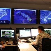
As a matter of standard practice, our dispatchers monitor all weather types 24/7. Our primary tool is the National Weather Service (NWS), and the equivalent government weather services in other countries. For example, in Japan, it’s the Japan Meteorological Agency (JMA).
Specialized tools, (depicted below) allow dispatchers to visualize this information in a manner that best supports the decision making process.
Each of these services is approved by the Federal Aviation Administration (FAA) for our use. Forecasts are issued roughly every six to eight hours. Since 1992’s Hurricane Iniki, the most powerful hurricane to strike our state, satellites and forecast modeling have significantly improved. Every event is also researched and used as an opportunity to further develop and progress our modeling. Throughout this entire process, our dispatch also maintains close contact with the NWS, Joint Typhoon Warning Center (JTWC), Air Traffic Control System Command Center (ATCSCC) and several other agencies.
In Hawai‘i, hurricane season runs from June to November. How did your team track the recent Hurricane Lane as it gained strength and moved through the Pacific Ocean before dissipating into a tropical depression as it got closer to the islands?
During each forecast period, our dispatch team monitors new weather formation alerts. We review the prognostic reasoning and evaluate the threat. Sea surface temperatures (SST) are also evaluated to determine if they will allow the system to sustain, intensify (which occurs when it is 78 degrees Fahrenheit or warmer) or degrade.
Dispatch also looks at surface pressure systems to evaluate the steering mechanisms that may affect a storm. Upper atmosphere and jet stream systems, as well as trade wind patterns, are reviewed to see if there are any shearing mechanisms to degrade the storm. Proximity to the Hawaiian Islands and surface friction can also influence the storm system.
Specific to Hurricane Lane, all stakeholders met four days prior to forecasted CPA to review the pending threat and plan accordingly. Lane was tracked very closely every eight hours, and updates were frequently distributed along with our latest operational plans. Early models indicated Lane would pass very close or possibly impact O‘ahu, so a fleet evacuation and staging plans were formulated. The storm then slowed and tracked off the islands, changing our approach to the schedule and timeline. Once subsequent models showed a continued slowing and degradation pattern, we decided to take a tactical, airport-specific focus instead of a holistic operational posture. Crosswind components with wind shear, heavy rain causing low visibility and infrastructure constraints – government and vendor support staffing, transportation, power outages or structural damage - were some of the factors considered at each airport.
How can hurricanes affect flight operations, and what does it take to cancel a flight due to a hurricane?
Hurricanes impact flight operations when, in close enough proximity, they yield low visibility with heavy rain, strong wind shear with crosswind/tailwind components beyond what our aircraft can handle, and the potential flooding of runways and airport facilities. Extremely strong wind gusts can also create hazardous conditions for normal aircraft operations on the ground such as opening doors, attaching jet bridges, refueling, among others.
All aircraft and airport risk factors are considered with a margin of safety to allow for contingencies. Flights may be canceled or delayed extensively when any of the factors considered can’t be mitigated in a safe and timely manner.
How does Hawaiian train pilots to prepare them to fly in strong weather?
Hawaiian Airlines hires highly skilled pilots, many of whom have experience operating on the mainland and internationally where they have employed thunderstorm avoidance procedures and operated safely in winter weather conditions. All of our company’s training curricula are designed to meet or exceed FAA requirements. This includes guidance on thunderstorm avoidance, cold weather procedures, turbulent conditions, and operating in areas where volcanic ash may be encountered. Our pilots are trained to recognize conditions that may be inadvisable to operate in and in such cases will avoid the area, delay, or proceed to an alternate airport, if necessary.
Pilots return annually for refresher courses on adverse weather conditions and meteorology — including interpreting weather charts and maps associated with their flight route. Scenario-based training in our advanced simulators typically features adverse weather conditions, such as low visibility and strong crosswinds. Through cutting-edge simulation, we can train our pilots to navigate conditions that are far worse than those typically encountered in normal operations.
Whether flying to a neighbor island, an international destination or the U.S. mainland, Hawaiian Airlines pilots safely operate in all types of weather conditions by using their knowledge, skill, and training to provide our guests with a safe, comfortable, and memorable flight to Hawai‘i and back home. If conditions have been deemed too hazardous, they can make the appropriate call to maintain the safety of both our guests and cabin crew.
